
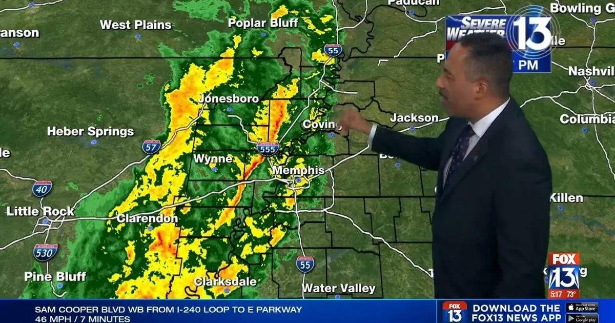
MEMPHIS, TN — A flood advisory was issued Tuesday night for parts of the Mid-South as heavy rain and thunderstorms moved through the region. The National Weather Service office in Memphis posted the advisory at 8:14 p.m. for Shelby County, Tennessee, and DeSoto County, Mississippi.
The alert was set to remain in effect until 11:15 p.m. as showers and storms tracked from west to east. Forecasters warned that the rain could lead to localized flooding in low-lying or poorly drained areas while the stronger parts of the system continued eastward.
Storms were expected to cross Memphis and surrounding areas during the evening
Weather timing from FOX13 Memphis showed storms beginning in eastern Arkansas before moving into the Memphis area and nearby communities later in the evening. The forecast called for storms to move through Memphis, West Tennessee and northwest Mississippi between about 5 p.m. and 8 p.m.
After 8 p.m., the storm line was expected to shift east of Shelby County and east of DeSoto County. The evening forecast also said showers and thunderstorms were most likely before midnight, with rain tapering off toward dawn.
Conditions were expected to stay cooler and breezy overnight, with lows in the 50s to near 60 degrees and south winds around 10 to 15 mph.
Weather service said flooding was one of several risks with the system
The National Weather Service listed flooding as a medium threat with the Tuesday setup. It also flagged the possibility of damaging wind, described as a low-to-medium threat, along with a low chance of a spin-up tornado.
Officials said the Mid-South was under a marginal risk, or Level 1 of 5, for strong to severe storms on Election Day. That means isolated severe weather was possible, but widespread severe storms were not the main expectation.
The forecast emphasized that the strongest impacts would likely come from heavy rain and embedded thunderstorms rather than an organized severe outbreak.
Wednesday was expected to turn cooler with gusty winds and only a slight rain chance
Conditions were expected to improve after the overnight storms passed. Wednesday’s forecast called for mostly to partly sunny skies, cooler air and a brisk feel across the Memphis area.
The day’s high was forecast to reach the upper 60s to near 70 degrees, with southeast winds at 10 to 20 mph and gusts reaching 30 to 35 mph. Forecasters also mentioned only a slight chance of an afternoon sprinkle.
Sunrise was listed for 6:24 a.m. CT, while the broader outlook pointed to a shift toward calmer and cooler weather for the rest of the week.
The rest of the week was forecast to stay sunny, cool and breezy
After Wednesday, the region was expected to settle into a stretch of clearer fall weather. Thursday’s forecast called for sunny skies and temperatures near 70 degrees, followed by mostly sunny and cool conditions Friday with highs in the mid-60s.
The weekend outlook looked similar, with mostly sunny and cool weather Saturday. Morning lows were expected to fall into the upper 30s and 40s, while daytime highs were forecast in the mid-60s.
Sunday and Monday were also expected to be sunny and cool, with morning lows in the 30s and low 40s and afternoon highs in the upper 60s on Sunday and the mid-60s on Monday.
FOX13 urged viewers to keep weather alerts turned on for fast-changing conditions
Because the storm timing could shift and localized flooding can develop quickly, FOX13 Memphis encouraged viewers to use its app for breaking weather alerts in their neighborhoods. The advisory was aimed at helping residents in Shelby and DeSoto counties stay aware of changing rain and thunderstorm impacts during the evening.
With the advisory lasting only a few hours, the main concern for most people was the combination of heavy downpours and brief flooding in vulnerable spots. Forecasters expected the system to move away by daybreak, but the evening hours still carried the highest risk for travel trouble and ponding on roads.
